Hi @Lee
thanks for your reply.
I need to sync with @MariaAM but as I was writing in the previous message,
I think the following can be presented to plenary:
A small recap on the what has been done till now
The fiche reviewed
A proposal for the pilot scouting exercise in these two areas:
the Anderlecht area from Maria the Forest area from the map I proposed (btw they are connected)
Call to action for volunteers
Planning of the two pilot scouting exercise.
But again, I will confirmed after sync with @MariaAM.
great! i am going to see Vincent from the squat movement next monday at 16. he might have a concrete scouting methodology (lie’s Technical Organisation point). you are welcome to join, (in french)
Dear all,
Very quick post because it’s late
I just tried to put together some maps to get an idea of which areas to exclude (based on the criteria in the blueprint). I only took the maps that I could easily find, and I didn’t care about resolution. I’m sure a better job could be done with time, but I actually think that it is not necessary to get a good idea of where not to look
In photoshop, I can obviously overlay individual maps as needed, but for a quick idea I’m just going to share a pdf with you where each page is one of the maps: https://c301.nl.tabdigital.eu/f/60304
(The bookmarks tell you what page shows what.)
Let me know what you think, and please share any other interesting maps with me that you might have.
Good night!
Hi @manuelpueyo , thanks.
I’ve reviewed the fiche mentioned by @Lee and it is very basic and it is not clear how and if they/we are able to gather the necessary info during the scouting exercise. I created a new folder and there you can find the original fiche and a new template I tried to adapt. You can find some comments at the end. Unfortunately tomorrow at that time I will be working. If you have time, thanks if you can share them with Vincent. Thanks, MC
this is a database that is filled by different people and students. they are scouting the city in search of empty houses to squat
this is not the original source. it is a download from the original source. which is hosted in Zohodocs and I have the access. if we want to collaborate with them they are open to receive our contributions to the original table.
or we can just use our own table and use theirs as inspiration.
the email with instructions
this is just a basic email with instructions on how to fill the table. it’s to keep entries as harmonious as possible
other tools vincent mentioned
brugis
you can use this to know the surface of a parcel for example bru gis
I’m very late, sorry. @Lee, I prepared a small draft here, if you think it makes sense I can present it tomorrow, If not no problems.
Btw related to the membership process, tomorrow I would like to openly discuss with you about my time availability and decide how to proceed.
Hope today went well, see you tomorrow.
Thank you ! i see a big problem on the template. it’s better to insert the data in a format that is exportable by computers. this way you may want to use that data to visualize all options in a map or other data analysis and manipulation tools . i have added some templates examples above,
PILOT ANDERLECHT
Hello everybody (specifically people who volunteered for this exercise @alberto@Dave_Starhawk@ugne@VickyVanEyck@RichardB and for info: @MariaClaudia ),
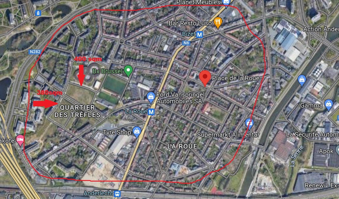
For the scouting exercise on Sunday, I propose the following area:
This area is in metro line 1/5 and has some open spaces that I have measured with google satellite (while I have 0 Photoshop skills, I have very advanced Paint skills ). I think it is an interesting area not only because it is connected to a main metro line, but also has supermarkets around and the canal is a friendly-cycling area. Other assets: green spaces nearby and the swimming pool of Ceria.
This is the map of floods, the area is quite safe:
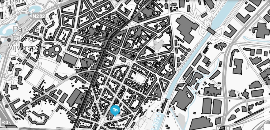
This is the map of buildings (just relevant to see empty spaces, but there might be abandoned spaces that are not reflected on this map):
I am not sure if we can cover all of it in aprox 3 hours? of scouting, but we can see how far we can go. I know many people volunteer, but I don’t think we need to be many for a first pilot (2/3 people + me). However, everybody is welcome I suggest we meet on Sunday at 11.00 at the metro stop of Bizet and start from there.
Just a kind warning: I might be disconnected from Edgeryders until Saturday evening. If there is anything urgent, please contact me via Signal.
Thanks @MariaAM , looks great, thank you!
Are we talking already about this Sunday 2 April as i will be traveling, so not available. I poke @manuelpueyo so he sees it. Not sure he will be able to do it with Ada but he was interested in helping.
Hmm, I did not pay attention that this landed on Sunday. I am out of town this one (2nd April), just like @ugne. If that is the day, count me out. Sorry!
This is a new tool for offline data collection based on open street map that can be evaluated for the scouting exercise
‘The Sketch Map Tool is an easy-to-use tool for participatory sketch mapping through offline collection, digitization and georeferencing of local spatial knowledge.
The tool has a variety of applications. For example, do you want to work together with people in a community to map their experience and perception of risk in their neighbourhood in a paper-based format, but still be able to quickly analyse the results digitally? Then, the Sketch Map Tool is exactly what you need’
 ). I think it is an interesting area not only because it is connected to a main metro line, but also has supermarkets around and the canal is a friendly-cycling area. Other assets: green spaces nearby and the swimming pool of Ceria.
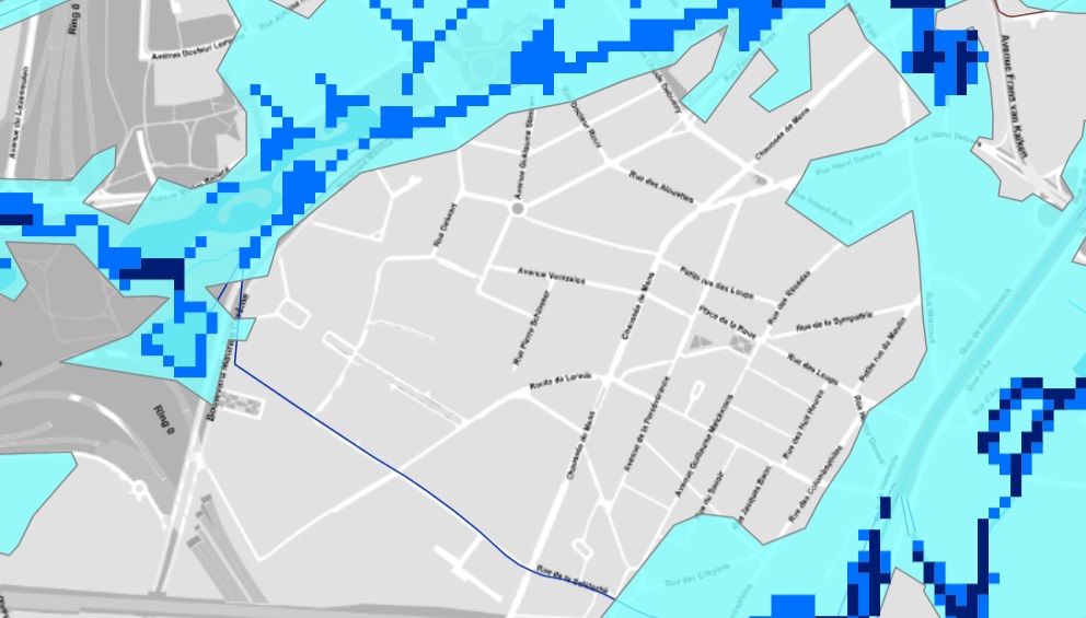
 I suggest we meet on Sunday at 11.00 at the metro stop of Bizet and start from there.