Good evening everybody,
I’ve been trying to move on with my homework on the scouting and I wonder if @Lee would have an idea of who did it in Brutopia i.e. our Brutopian counterparts in team building (info also welcome if we can have it from other co-housing projects). Or how we can find them ourselves (maybe our contact point with the architects could help us?). We can maybe learn about alternative real state/ industrial properties apps/sites.
Also, I have found what seems to be and interesting tool:
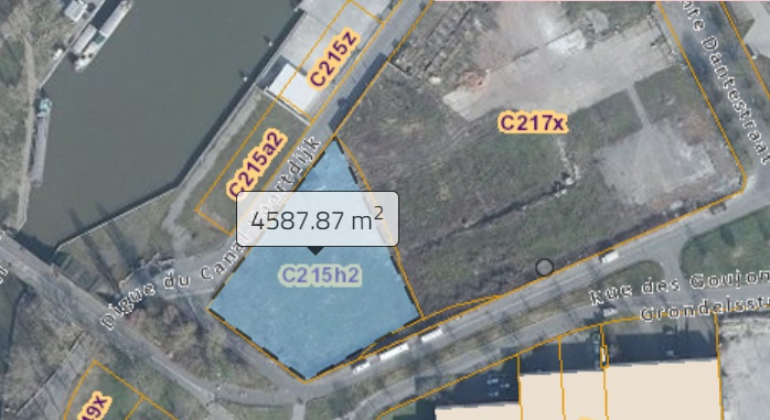
The map of the “cadastre” CadGIS This map has a tool to measure distances. Google Earth also has this tool, but in this map it appears together with the name of the ‘terrain’, which might help us to find the owner if we give this info to the commune. Example
Thanks a million @MariaAM! I took the liberty to move your post to a separate topic, because this knowledge is too valuable to get snowed under in the day-to-day Team Building exchanges.
To answer your question: I am not 100% sure, but my intuition is that the other cohousings just went in without too much analysis. In Brutopia for example we know that they skipped a couple of communes like Watermael-Boitsfort because they are too expensive and full anyway, but other than that they just cut up the map of Brussels and went out. That being said I think it would be a good idea to reach out to your colleagues from the “GT Architecture” from Brutopia, l’Echappée, Ilot De Spiegel and Tivoli, because they may have a lot of good advise that will spare us a lot of misery. A good starting point is the manual that was written by l’Echappée.
Hey all, I have learned in our Finance meeting today that you will soon be starting the scouting exercise and I would like to volunteer to scout with you for sites. I should have availability as of mid of the month. Weekends and in particular Sundays work best for me for the moment.
For the contact of other team building/scouting: @MariaClaudia@MariaAM : will you be visiting casa nova this weekend? If not we can ask them the question for you.
I also have the contact of somebody at corouble (where they bought a whole Spanish Embassy!), I put you in contact with them.
For Tivoli, Ivwas thinking to try to organise a visit, so I’ll be contacting them and can ask for a contact at the same time… (or if your prefer, team building can contact them if you would prefer to organise visits from now on
utilities. electicity or gas companies. could we have data of buildings that are not consuming at all?
maybe plan a post on social media + nesletter announcing what we are looking for and get all the reeflings like it at the same time so that it becomes viral.
please keep me in the loop of scouting since i think i can add value here. cheers !
So we asked, and it’s not very helpful nor cheerful-ing…
They’d been looking for a year and a half and were quite depressed. And they ended up finding a developer that was willing to sell them the site and the appartements to be built (but it was somebody they knew though, so not sure if that’s replicable…)
Three things that could be helpful though:
they mentioned that the developer was willing to sell because its project had been refused by the commune cause he wanted to pack in too many appartements… That point came out at another point of the conversation, so it could be a thing if we can have access to some kind of record with rejected projects…
look for places that developper don’t like, such as “interieur d’ilot”
they said that the meetings for “contrats de quartier” were probably an incredibly valuable thing for us, as the people there know the neighborhood extremely well. And because their hidden agenda is to gentrify neighborhoods (side note, I hate it that gentrification is probably what we will be… but at the same time, it will happen one way or the other and at least we would (hopefully) be a positive gentrification, with benefits for the local community… so I guess we’re ok…)
Also somebody mentionned that there are some empty spaces right by l’échappée…
So there’s that!
Happy to be kept in the loop too, and happy to help as well! This is exciting!
hi everyone! I quickly wanted to check in with @leonard , @MariaClaudia and @MariaAM to see how the scouting exercise is going. Is there any help you’d need from me? @Lee has also asked if any more help is needed with this task, so feel free to pull her in to this too
Hello everyone,
As mentioned during the last Team Building, I am quite busy preparing a series of exams that will take place during the whole month of March. I am therefore not having much time for the Reef lately. Maria Claudia (who I believe is busy with the same thing ) and I haven’t touched based with the scouting exercise for a while now. I’m not sure we will have much to present by the end of March, I hope I’ll be more relieved (and released) from duties in a few days and maybe we can discuss it and let you know exactly where we are.
As I said during our last meeting, I’ll be happy to have a go at the map(s) with photoshop or similar, but I don’t think it makes sense for me to search for maps if others already have them. So, as agreed during our meeting, I’ll wait for input from the others and then put that together as soon as possible.
I really sympathise with the fact that you need time to prepare for the exams. It’s clear that this take precedence. I’ll cross my fingers for you!
At the same time this task is so important that I would like to be able to be 100% sure that we can discuss the proposal at the plenary meeting of 23/03. Would it please be possible to let us know whether this will be possible, or else whether we need to call in help from other people?
Taking one step back (@reef-building) I am feeling a little worried about whether the purpose of this task is fully clear, so I am going to take the liberty of listing a couple of things that I think we need in the proposal:
A technical fiche: we have a copy from another group, that just needs translations and a couple of minor changes.
Experience: it would be great if a couple of people could do a pilot on a certain area, so that they can write up a couple of things they learned. This way we’ll learn how much time it takes to scout a certain area. And equally important: this way other Reeflings can scout the area that they’ll be attributed with all the knowledge that they need to do the job.
Priority areas: Because we probably won’t be able to scout all of Brussels at the same time, it’s probably a good idea to identify a couple of areas that are the most likely to include a suitable site. This could be done by overlapping some maps, but you could also keep it very simple and start off with a couple of areas going from Forest up to Laken.
Technical organisation: I’m less clear on this aspect, but what I imagine is that the people who will coordinate this exercise will have an overview of who is scouting which areas, and possibly also ask people to report back on a regular basis, so that we know which areas have been scouted, and what were the findings.
The most time-intensive sub-tasks are probably the first two ones. If you would need help with those, can you please reach out so that we can find people who can take care of it? Other than that I would think that the entire proposal should fit on less than two pages, so hopefully this shouldn’t take too much time.
Please don’t hesitate to contact me if you need further help!
would be nice to come up with an existing methodology for this.
a group of people walk the city in search of spaces that share some attributes (looks empty, this size,e tc.)
how might we use a tool or process that allows them to encode their findings easily, on the go… … even having fun while they do it. some kind of city explorers,
Thanks a lot for your message and for the proposals.
As you said, we are probably complicating things more than necessary, and at the same time, we are all new to this type of exercise. Of course, we will improve and assess this in terms of cost benefits.
Background activities:
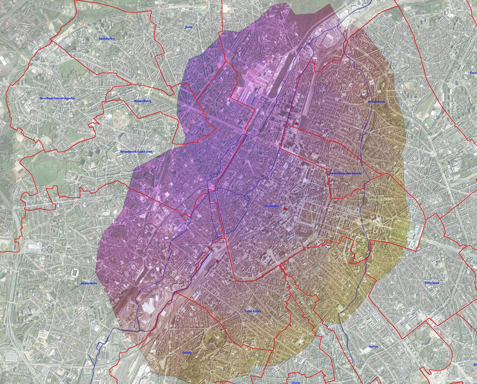
I created a map with the area in Brussels you can reach within 30 min walking using specific APIs from the three main train stations (see below, high resolution image will be stored in nextCloud): We already discussed that this is not aligned with the project requirements (30 min with public transport), but at least it is a valid starting point for testing the scouting exercise. I assessed other potential tools and APIs to improve the map using multi-mode transportation, but it is not straightforward.
@MariaAM Invested time in checking different maps related to pollution, green areas and other requirements and intersecting them: it turned out that Anderlecht seems to be an excellent area to start with the exercise.
This is the current state of the art, and we propose the following:
We look at the fiche you mentioned and review it (thanks if you can share the link)
We draft a basic template and basic checklist, based on the fiche and new inputs, that can be used for the scouting exercise.
At the plenary, we will recap the info above and propose how to perform the scouting exercise in two areas: the Anderlecht area from Maria and the Forest area from the map I proposed (btw they are connected)
We ask for volunteers and plan the two scouting pilots.
We collect and evaluate the feedback and assess how we can improve and if the exercise meets our goals.
Please let us know if you think this can be enough to start and aligned with your expectations.
Thanks a lot for the detailed plan on the way forward.
Two little points:
The “technical fiche” that I referred to I believe has the same function as the “basic template and basic checklist” that you refer to, so hopefully that should reduce the work that has to be done a bit. This is the internal link to the technical fiche that we received from the coach (it’s in the Team Building folder): https://c301.nl.tabdigital.eu/f/22543
Would it be possible to give me an indication of what you can do by when? E.g. will you be able to present something at the plenary of 23/03? And if yes, would this be based on what you learned from the pilot, or will this come later on?
As a background, this is what I think the group’s needs are:
At the plenary of 23/03 the group needs to get an idea of which areas are the most likely to contain a site that meets our criteria (important for expectation management)
My hope is that at the plenary of 17/04 we will be fully ready to move forward, so by then the entire system should ideally be operational (“technical organisation” in my post above)
Thanks a lot in advance and good luck with the exams!

 ) and I haven’t touched based with the scouting exercise for a while now. I’m not sure we will have much to present by the end of March, I hope I’ll be more relieved (and released) from duties in a few days and maybe we can discuss it and let you know exactly where we are.