Small steps towards The Reef Brussels: isochrone maps

At our latest meeting, I promised to look up online services to help us select locations in the city based on convenience. “The 19 communes” is not precise enough, and might lead to frustration as someone suggests a place and someone else rejects it on the basis of a criterion that we had not considered before.

A criterion that did come up a lot is public transport. A concept that helps here is that of isochrone maps: the idea is to draw a curve on a map. Each point on the curve takes the same time to get to from some point chosen.

There are some API services to compute isochrones based on OpenStreetMap, the Wikipedia of geography. Here is one for walking distances from Gare du Midi. The area shaded in purple is reachable on foot in 10 minutes from the station; that shaded in red (which includes my current home, yay!) in 20.

You can make your own tests here. Just enter the address that you are interested, your mode of transport, and the maximum length of travel time.

This particular website covers walking, biking and driving, but not public transport. There are services that do like Iso4app, but it is a little more complicated, because it requires registration, generating an API key and maybe some fooling around with the software. Happy to do it, though, on prompts from the group.

Also reached out to Giuseppe, will keep you in the loop. Paging @Lee, @Sabine_B_Frank, Ugne, @manuelpueyo, @Malcolm.

1 Like

Update: Giuseppe @porcarorama is happy to take part in the next meeting. Welcome!

1 Like

Thanks a lot Alberto, very useful! And welcome Giuseppe!

The map inspired me to look up noise pollution from air traffic. Below is a copy from 2016, more maps can be found here: https://environnement.brussels/thematiques/bruit/donnees-bruit/cartographie-et-exposition-de-la-population/cartographie-du-bruit-du

Oh man! And then my Inner Nerd broke loose :blush:. Ready?

It turns out that Bruxelles Environnement produces quite a lot of maps as a matter of fact.

This is noise pollution from road traffic:

Source: https://environnement.brussels/thematiques/bruit/donnees-bruit/cartographie-et-exposition-de-la-population/cartographie-du-bruit-0

Air pollution seems more difficult to find though. There are a couple of websites that offer real-time data on PM and NO2, but nothing that is compatible with my (very limited) IT skills.

This one does not have a legend, but seems to provide a good overview:

Air pollution undefined.PNG

Source: Zone de basse émission : une mesure nécessaire mais insuffisante – ARAU

And then finally - nothing we didn’t know already, but just for the sake of future-proofing - warmest and coldest areas:

The more interesting part about this one is a more detailed zoom, which shows the impact of green spaces, not only parks but also blocks within streets that have a lot of trees:

Source: Bruxelles-Environnement dévoile une carte des zones les plus chaudes de la Région bruxelloise - BX1

So that! Lots of maps! Let’s maybe get together soon-ish again?

Cheers!

3 Likes

talking about giuseppe, he is my neighbor in the marolles, we had a nice interview yesterday, in which i asked him some questions about his vision of the project. I think we have a lot of similar views. but you can listen to it by yourself when you have a time. i uploaded it to soundcloud, (hope you dont mind giuseppe). does anyone else want to be interviewed? cheers

1 Like

these are pretty cool maps, they can guide us in our decission making. Thank you lee and alberto for sharing

Thank you @alberto for exploring isochrome maps! I suppose, if we all agreed that we would want to live say, within 30’ by public transport from Gare du Midi that would be useful to help define our search area. But additionally there would be the criterion of proximity to a multi-modal public transport node, i.e. avoiding living just near a single bus line, to mention an extreme. I don’t know whether there is a tool to help identify such areas and with which one could play with different ambition levels.
And indeed @Lee, so many other considerations for choosing a location - thanks for pulling out all these relevant maps!

What about our other ‘next steps’? @Lee, you mentioned that you’d want to talk to Brutopia and La Montagne before considering an appointment with Cohousing Projects, right? How could I help?

Then there was the suggestion of dinner together. @Malcolm and I would be happy to host from 9th June

Welcome @porcarorama! Thanks for the interview @manuelpueyo - will listen next!

2 Likes

Thanks a lot @Sabine_B_Frank and @Malcolm for the invitation!

I have had another moment of brain hyperactivity, and so I have taken the liberty to start another thread about the practical stuff so that it doesn’t get mixed up too much with the more informational stuff.

On Brutopia and La Montagne I haven’t undertaken any action yet, mostly because I think we’re going to get more out of this once the vaccination campaign moves forward and meeting up with people will be easier again. Based on another train of thought on defining what it is that we are looking for I floated the idea of setting up a sort of “co-housing road trip”. Maybe we can combine these two ideas into one?

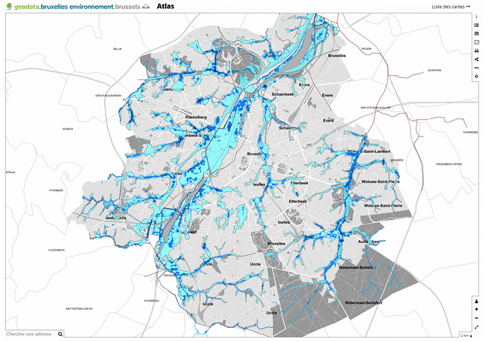
Oh, and finally my Inner Nerd asks to be excused for the obvious oversight, because thanks to the EU Floods Directive public authorities are obliged to publish flood maps (for pluvial floods).
The best copy I could find for Brussels is this one:


Source: https://environnement.brussels/thematiques/eau/leau-bruxelles/eau-de-pluie-et-inondation/cartes-relatives-aux-inondations-pour-la

But then to make up for that oversight the search engine took me to a page that brings together all the maps about Brussels created by Bruxelles Environnement. Composting? 4G antennas? Accessibility? It’s all there. Have fun! => https://environnement.brussels/guichet/cartes
1 Like

I looked my current address up: not in a flood area, by maybe 20 meters:

image

A post was merged into an existing topic: Meetings and practical issues

One more service for isochrone maps: www.smappen.fr

This allows superimposing isochrones with different criteria. For example, in this one I look at max 15 minutes walk from the central point of various parks (25 minutes for Bois de la Cambre, though in this case the site does not compute from its central point but rather from somewhere on the western border).

1 Like

And one more, this one on parks and green spaces:

Source: Het Groene Netwerk by Leefmilieu Brussel (Kaart 6.1 p.4)

Or else the itinéraires de promenade du maillage vert (found in the street)

image

2 Likes

Here’s the most informative set of maps on inequality, health and environmental pollution that I’ve ever seen: Bruxelles Malade. Thanks @leonard for flagging this!

Caution to those with an inner nerd that easily gets triggered: it’s super intriguing but a veeery long read. @alberto and @Sarah don’t say I didn’t warn you eh :wink: :wink: :wink:

3 Likes

@alberto : here is the study we were looking at tonight :slight_smile:
Might also be helpful for @reef-building for screening sites…?

4 Likes

It really is wonderful.

They also have price indexes by commune in 1995 and 2020. This tells us where The Reef is going to be…

image

4 Likes

Two more for the list:

3 Likes

Here’s a map that may be useful for groups that are currently looking for a site.

A recent article in De Standaard mapped drug-related shootings: https://www.standaard.be/cnt/dmf20241223_95554743

A red symbol indicates a single shooting incident, while a blue indicates a so-called “hotspot” (a lot of drug-related criminality):

I would personally not over-interpret the red symbols, but a map with the hotspots I would personally have found useful, and I remember I found it relatively hard to find.