We are trying to assess the state and strength of the OpenStreetMap communities in FMG countries. OpenStreetMap is a wiki-style built map of the world. The advantage over better known maps like Google’s is, of course, that OSM is a wiki; communities can edit, improve and rebuild – and even build from scratch. Google does not go to rural Pakistan, because there is no money to be made there; but rural Pakistani still need maps, so they can build their own on OSM. OSM is like Wikipedia: a global commons that grounds many, many things, most of which have not emerged yet. For now, trust me: it is important.
Here’s how you do it, engagement managers:
Go to http://www.openstreetmap.org/
Register. You will need an account in order to contact mappers.
Find your capital. For example, Tbilisi: http://www.openstreetmap.org/relation/4479704#map=11/41.7321/44.8071
Note the end if the url (after "map="). those numbers are [zoom level]/[latitude]/[longitude]. You will need latitude and longitude: take note of them.
Now use this tool: http://resultmaps.neis-one.org/oooc?zoom=10&lon=[longitude]&lat=[latitude]&layers=B00TFFFFFT. You have to substitute [latitude] and [longitude] with the appropriate values: for example, Tbilisi is http://resultmaps.neis-one.org/oooc?zoom=10&lon=44.8071&lat=41.7321&layers=B00TFFFFFT
Use the filters to select the most active contributors only (from senior level on). You can, and should, zoom out to country level – you might find experienced rural geohackers, who are very precious.
Click on the icons representing the most senior contributors. A pop-up opens with statistics on the person. Explore them particularly important to us is the date of the latest contribution you find under "How did he/she contribute to OSM?". If the date is recent, the person is still active.
Click on "Visit osm.org usersite". Click on "send a message" and reach out to the person, asking her to meet you/join a call/ or connect you to the OSM community in any way.
We are looking for underutilised, underrepresented, skilled people. Chances are they exist, they are working on stuff, and they can be brought in.
Like Wikipedia these days, OSM has developed an organizational meta-level at least i some countries. It means that the most active openstreetmapper is for sure important, but there can be key persons who are not the most active ones in the map.
Example Georgia: Don’t know how active he personally is on the map, but Eric Barrett is definitely the key person for OSM in Georgia. He organized the whole 10-month-or-so mapping drive of the community to get Georgia on OSM, and the funding for it (which came from the international Jump Start organization, if I remember correctly when he told me the story).
@Alberto, does that make sense? If so, maybe the engagement managers could / should try to find out the key organizers as well.
This is one impressive website, way to go for open data!
There are no gold rated mappers in Africa/Middle East.
Most highly active mappers in Egypt are foreigners who stayed a bit in Egypt and so sort of irrelevant to us.
There are 2 senior + rated mappers in Cairo, thats all.
The are no Senior rated mappers in Egypt
You get some rated Junior, i.e. those who have between 100-500 changes. I actually recognised a name!
All of this was when limited to activity centers within the last 6 months. Relaxing that condition reveals a rather much more active community around 2010. @Alberto is their any data for total worldwide contribution to openstbreetmaps? Could it be that worldwide contribution peaked sometime, and then slowly dwindled?
I will contact a couple of people, but I am sure they are anything but under-utilised. I have a certain profile in mind and would love to see how it turns out.
Update: Its been 2 days since I contacted 6 persons, none have replied so far.
Out of 6 contacted persons (Senior & above), 1 replied with a wary interest. @Alberto assessing the strength the of the community, there is none in Egypt.
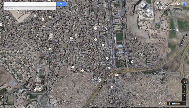
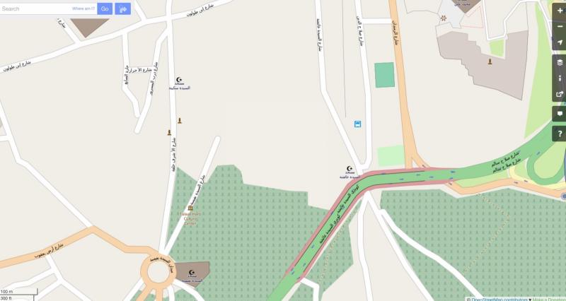
I did a small test: Compare 1 Satellite Imagery (Google Maps) with Map Data from 2 Google Maps and 3 Openstreetmaps for the same stretch of land.
Google Maps has a much higher resolution, that is actually quite good. Individual building are recognised, some are numbered, as are roads, as are Points of Interests.
Open Street Maps correctly categories the lower middle spot as a cemetery.
The question is: Given the far superior nature of the commercial product, does the truly open one stand a chance of realisation in the face of complete resource shortages? Is there sufficient demand for it?
The chosen geography is Darb el Labana where Megawra is situated, and where Mustafa hopes to commit his project. One could perform such a rudimentary analysis everywhere, and results might differ outside of Cairo. But then again so do the people and does the pool of potential contributors. The only potential avenue for true street mapping in Egypt now, I believe, is within the desert going community for their desert routes. This community already exists and is quite developed.
Lat/long refer to the Pompeii archaeological dig. The extra data were added by the community doing two “mapping parties”. People are now adding pictures with Mapillary, a sort of open source version of Street View built on top of OSM data.
Ok, if there is no community that’s that. But the demand question is irrelevant: you can only demand something you understand. Remember Henry Ford? “If I had asked my clients, they would have told me they needed a faster horse.”
Also, I find it really strange that @Hazem's crowd, Cluster etc. do not need heavily customized maps. The license of GoogleMaps is not open, so there are plenty of limits to what you can legally do with their data. How do they do their maps? Bespoke? Illegal reuse of Google data?
Regrading Megawra, I asked about their mapping practices.
For online use and publishing, they use Google Maps and Map Maker, due to its simplicity.
For internal use, which is quite heavy, they rely on professional proprietary Arc-GIS software.
They feel no particular benefit/ case for using OSM as their primarily mapping tool. Some mapping activities have been performed with the community as part of the Athar Lina project, where the final product has been a physical map put at the entrance of al-Khalifa street.
I have been in contact with the community here in Cairo. They are planning a how to use OSM workshop event sometime soon. Are there any readymade materials they could utilise for that? Can you put us in touch with active members of the international OSM community to follow up with?

%20copy.JPG)